
Hadrian's Wall: Turf, Stone and Milecastles
Hadrian's WallHadrians WallHadrian's Wall HistoryWho Built Hadrian's WallWhy Was Hadrian's Wall BuiltRoman Wall Britain
 Premiere coming soon
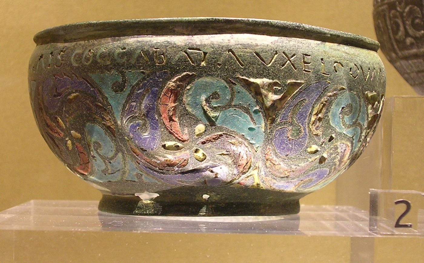
Staffordshire, England. 2003. A metal detector turns up a little bronze pan, decorated with bright enamel. It is about 9 centimetres across. Small enough to hold in one hand. Around the rim runs a line of Latin, with no clear beginning and no clear end. In it, four names: Mais. Congavata. Uxelodunum. Camboglanna. They are Roman forts. All four stood at the western end of Hadrian's Wall, more than 200 kilometres to the north. And four more words. Rigore vali Aeli Draconis. Vali means: of the Wall. And Aelius was Hadrian's own family name. So this little pan may tell us something no ancient book does. What the Romans called the Wall.
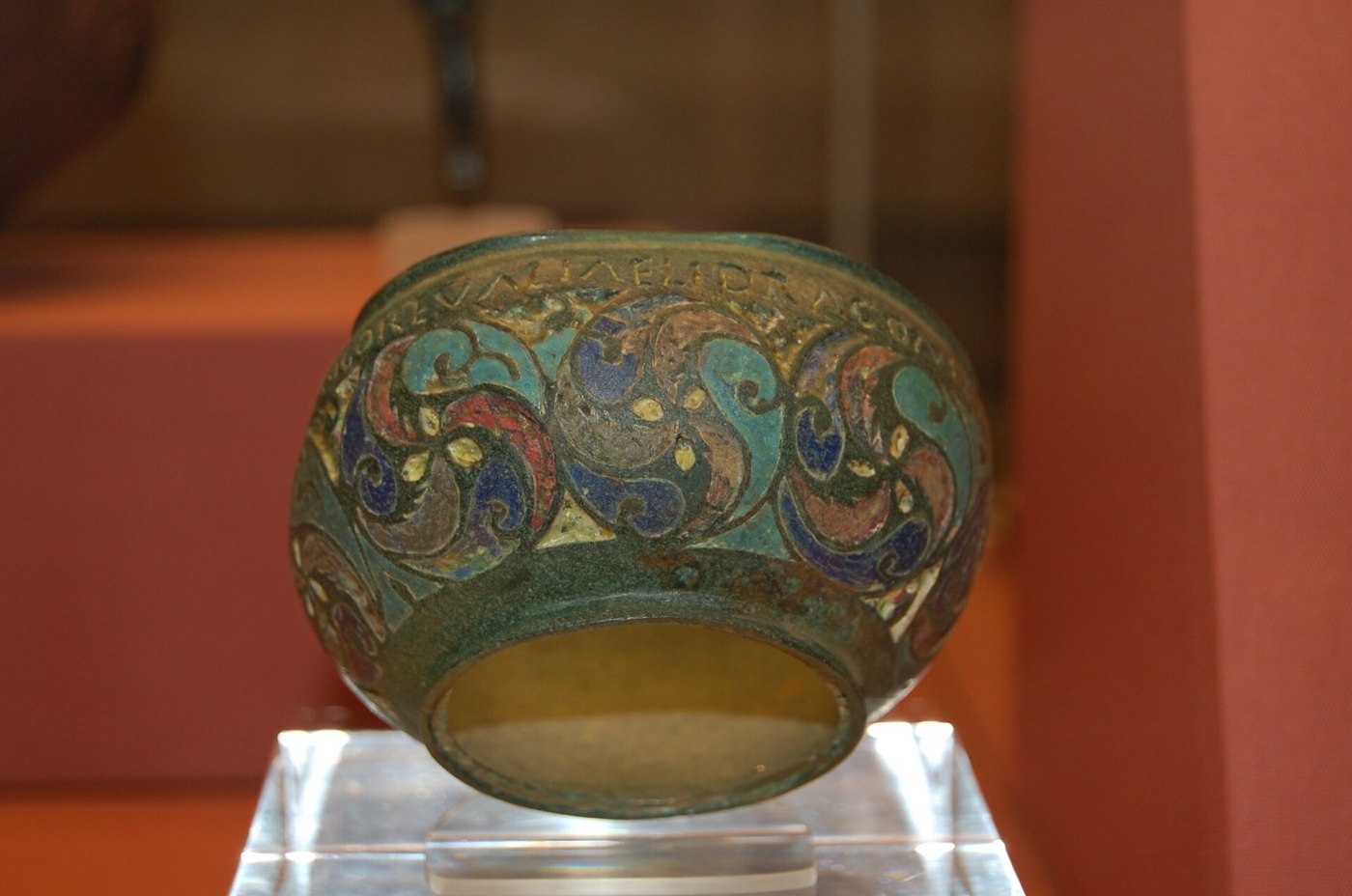
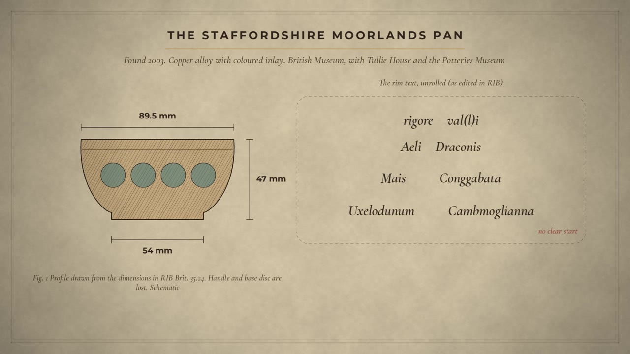
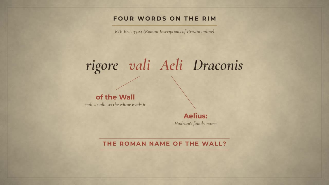
Did you know? The Roman name of Hadrian's Wall may survive on a souvenir pan about 9 cm across, found in Staffordshire in 2003: rigore vali Aeli Draconis. Whether Aeli means the Aelian Wall or is part of a man's name, Aelius Draco, is disputed (RIB Brit. 35.24; David Breeze).
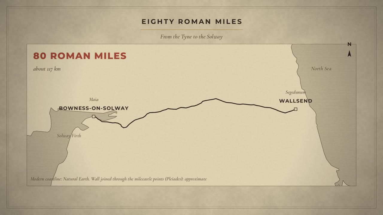
This is Hadrian's Wall. 80 Roman miles of stone and turf, right across Britain, from the river Tyne to the Solway. Today: what it was, what has been dug up, and what the texts really say. And the first surprise: the ancient writers almost never name Hadrian as its builder.
One sentence in the Historia Augusta
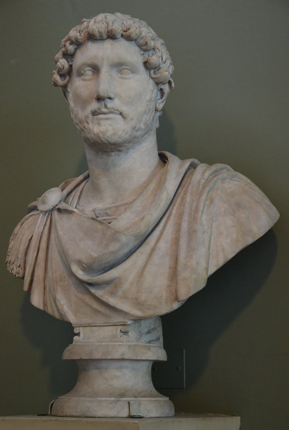
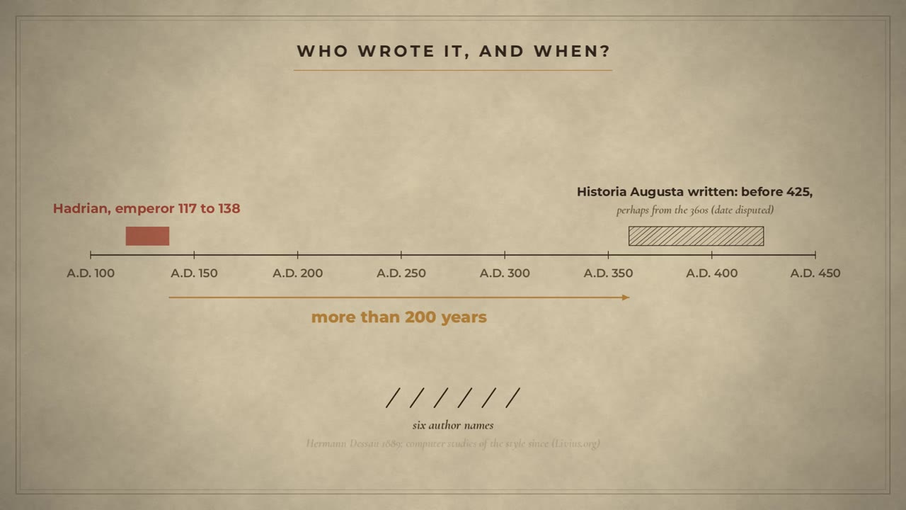
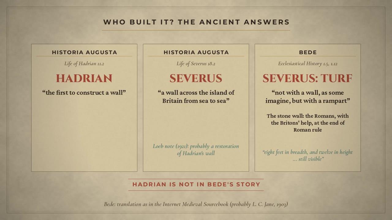
Of the ancient texts we know, one sentence gives it to Hadrian. It is in the Historia Augusta, a collection of the lives of the emperors. Hadrian, it says, went to Britain, set many things right, and was the first to build a wall, 80 miles long, to separate the barbarians from the Romans. But handle it with care. The collection was written more than 200 years after Hadrian, and most scholars now think by one author, who pretends to be six. And in the very next sentence, it says Hadrian sacked his secretary for letters. His name was Suetonius. The same Suetonius who told us how Caesar died, in our pugio episode.
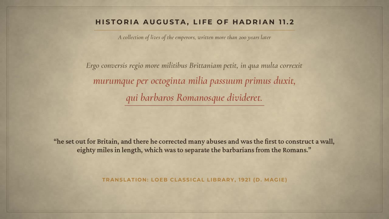
Did you know? The only ancient sentence we know that credits Hadrian with the Wall is followed at once by the sacking of his secretary for letters, Suetonius, the biographer of the Caesars (Historia Augusta, Life of Hadrian 11.2 to 11.3).
Severus, Bede, and a muddle
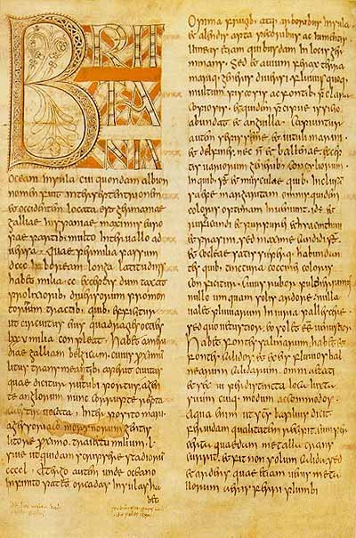
Later writers muddled it. The same collection, in its life of the emperor Septimius Severus, says that Severus built a wall across Britain, from sea to sea. A note in its Loeb edition of 1921 says this probably means a restoration of Hadrian's wall. And the monk Bede, at Jarrow, just a few miles from the Wall's eastern end, gives a different story again. Severus, he says, built a rampart of turf. The stone wall was built by the Romans, with the Britons' help, at the very end of Roman Britain. Eight feet broad, twelve feet high, and, he says, still to be seen. Hadrian is not in his story at all.
The proof is in the stones
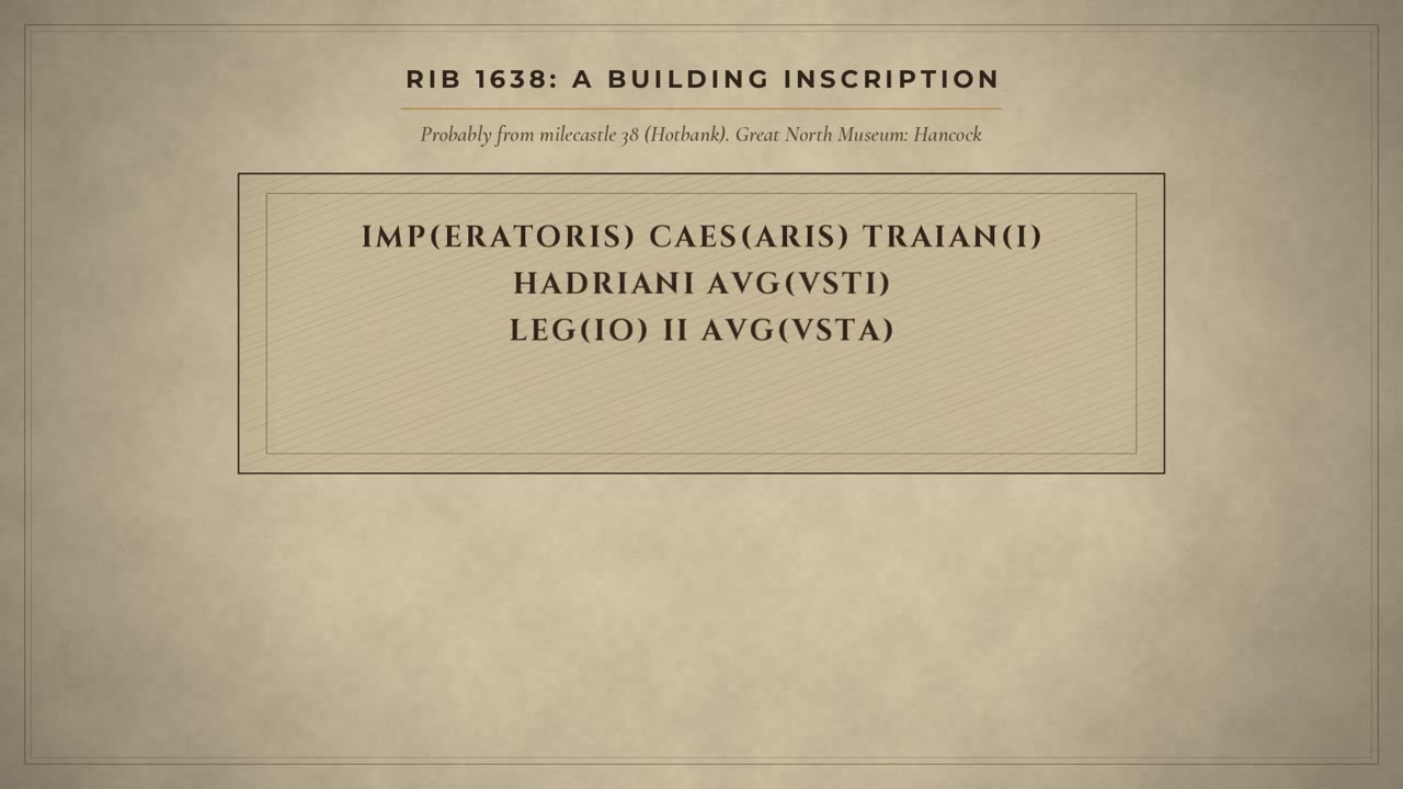
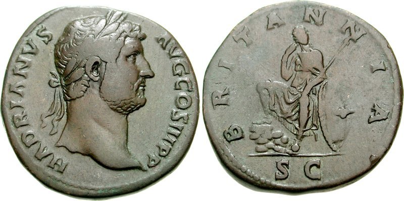
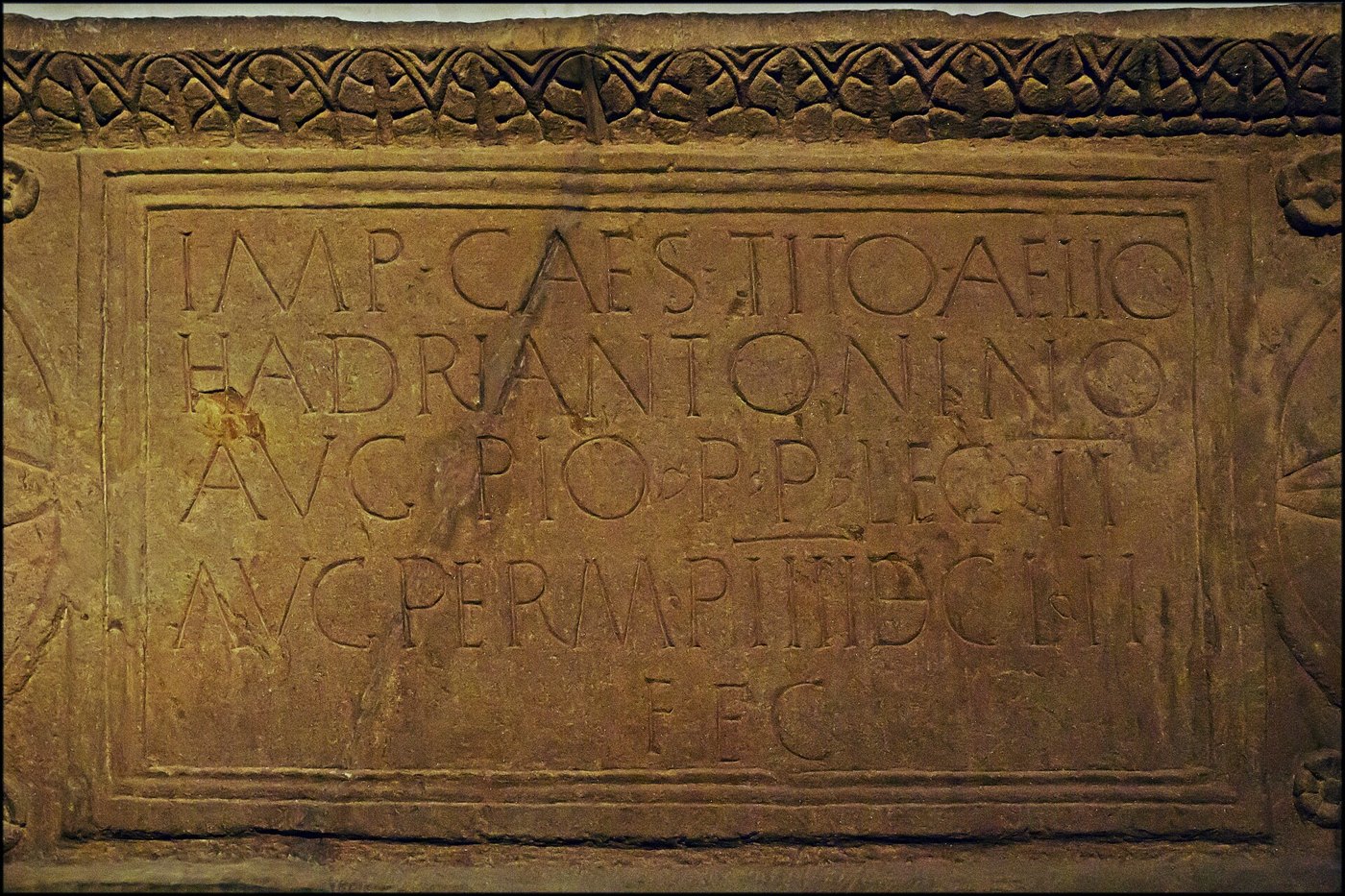
So how do we know it was Hadrian? From the stones themselves. This inscription probably comes from milecastle 38, in the middle of the Wall. The work of the emperor Caesar Trajan Hadrian Augustus. The Second Legion Augusta built it, under Aulus Platorius Nepos, the governor. Platorius Nepos governed Britain from about 122 to about 126. 122 is the year Hadrian came to Britain. And, says the archaeologist David Breeze, the Wall was built on his orders after that visit.
Before the Wall: the Stanegate
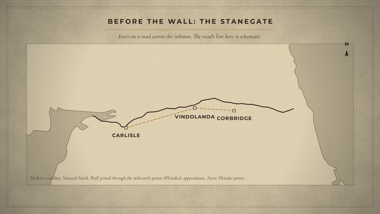
Hadrian did not start from nothing. Across this narrow neck of Britain, forts already stood along a road we now call the Stanegate, between Corbridge and Carlisle. Vindolanda, from our fort episode, was one of them. Paul Bidwell argues that Hadrian's first plan took in much of that older line. The Wall itself ran a little further north.
The plan: a gate every mile
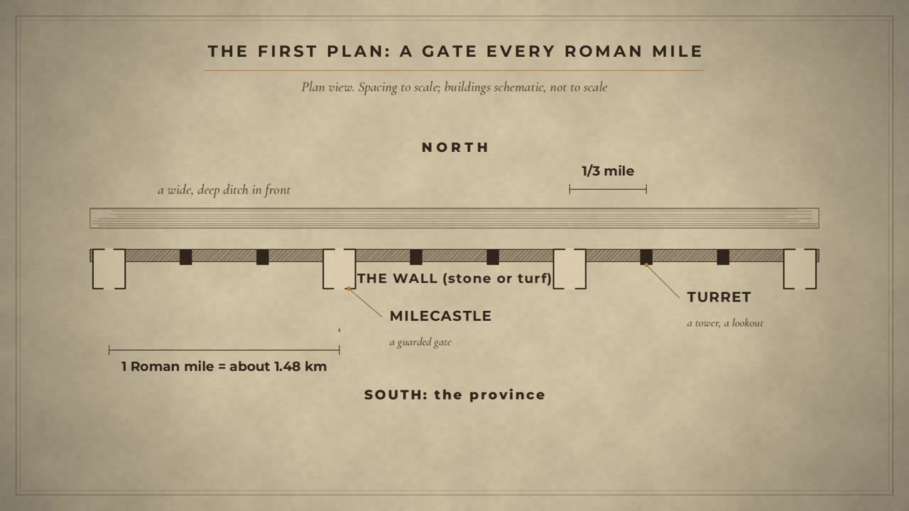
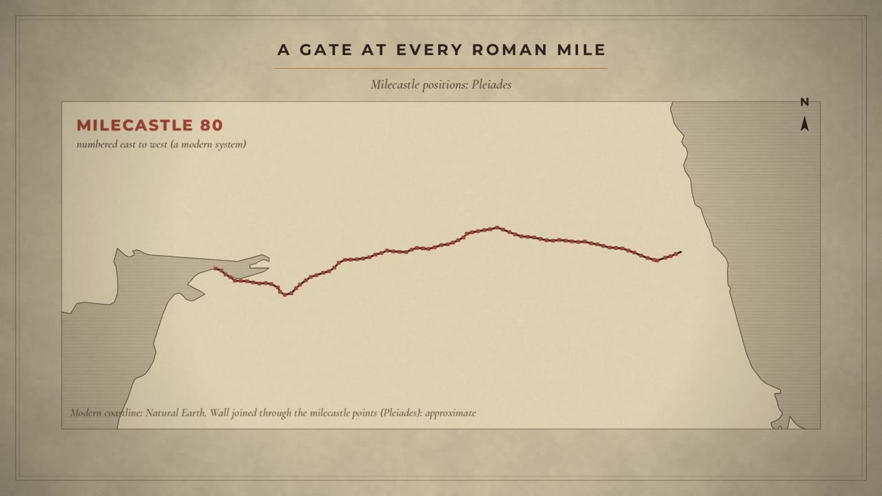
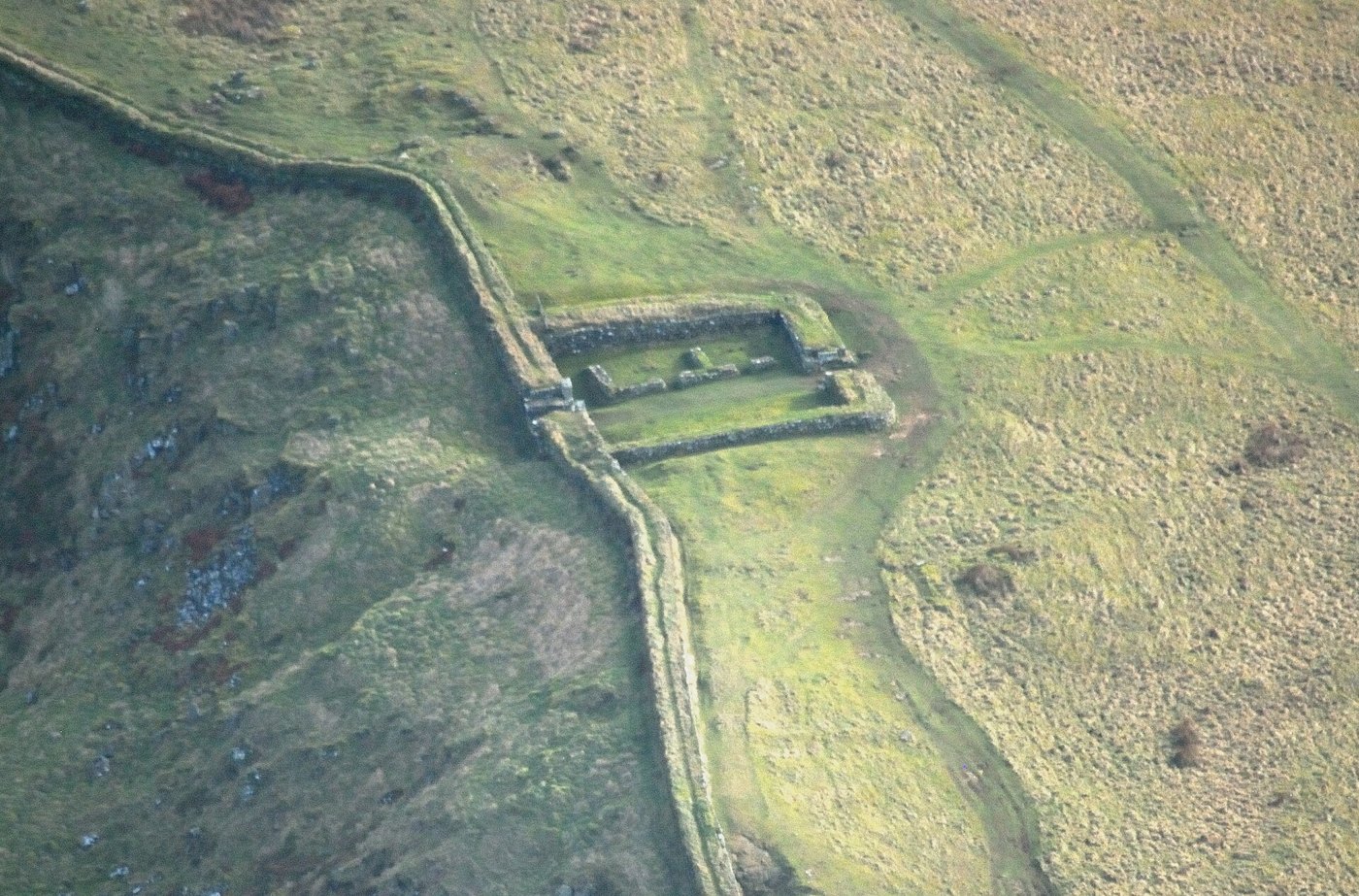
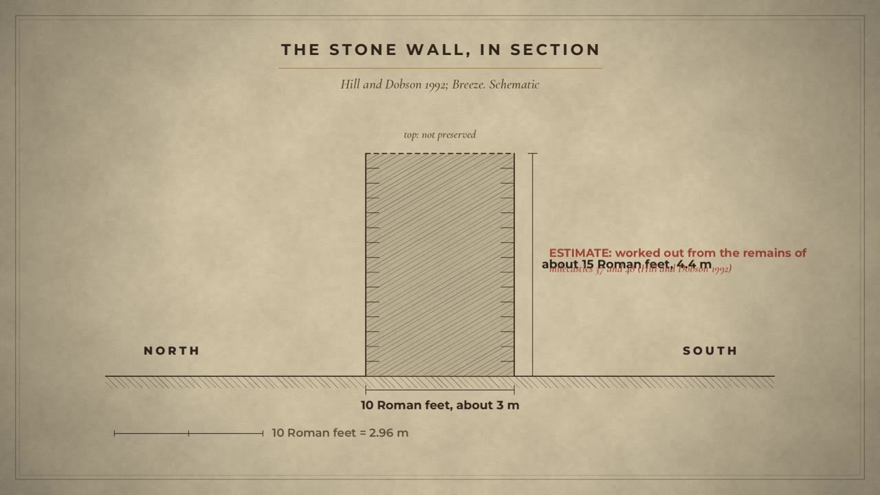
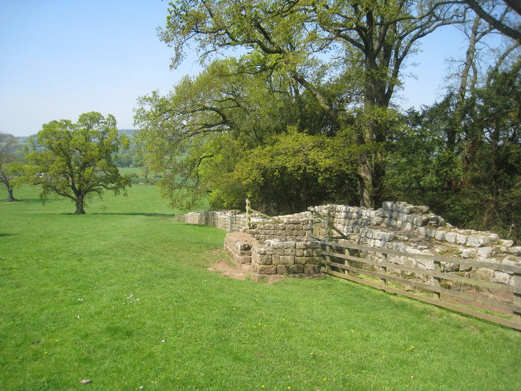
As first planned, the Wall was a wall of stone or turf, with a wide, deep ditch in front of it. At every Roman mile, about one and a half kilometres, there was a gate, guarded by a small fort we call a milecastle. Between each pair of milecastles stood two towers, called turrets. A lookout every third of a mile. A barrier with a gate roughly every mile. About eighty gates through a wall meant to separate. In the east, the stone wall was planned 10 Roman feet thick. About 3 metres. How high? Nowhere does it survive to its full height. From the remains of two milecastles, Peter Hill and Brian Dobson worked out a design height of about 15 Roman feet. Some 4.5 metres.
Turf in the west
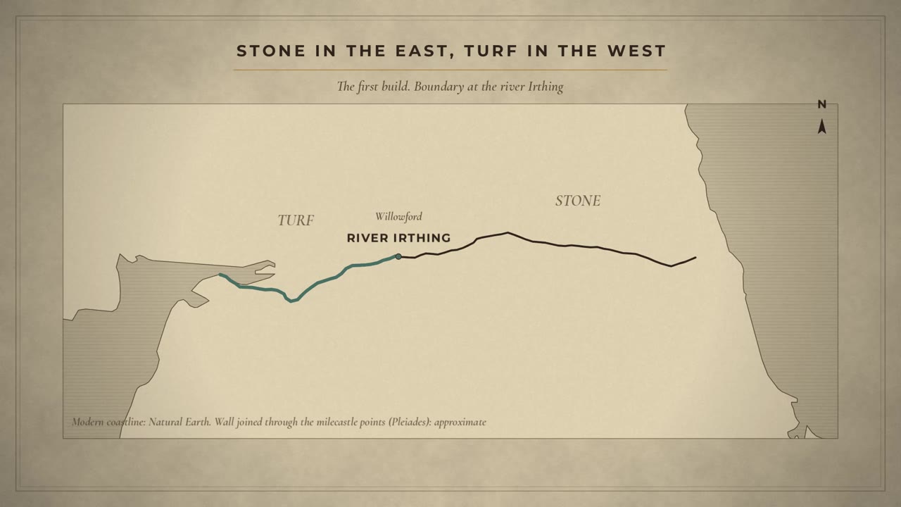
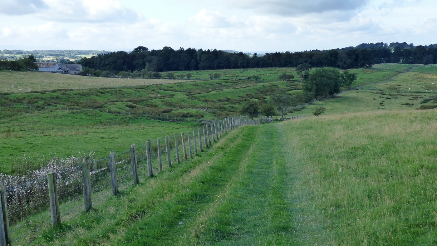
But the west was different. Beyond the river Irthing, the Wall was first built of turf. About the western 30 miles of the 80. A rampart 20 Roman feet wide, about 6 metres, with milecastles of turf and timber. Why turf? The sources we read don't settle it. Later, the turf was replaced in stone. At Birdoswald, the new stone wall even took a different line.
The plan changes in the stones
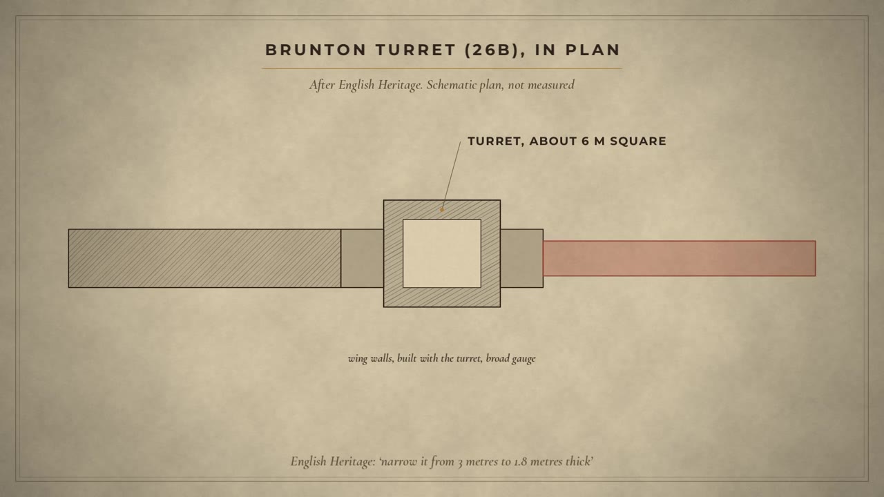
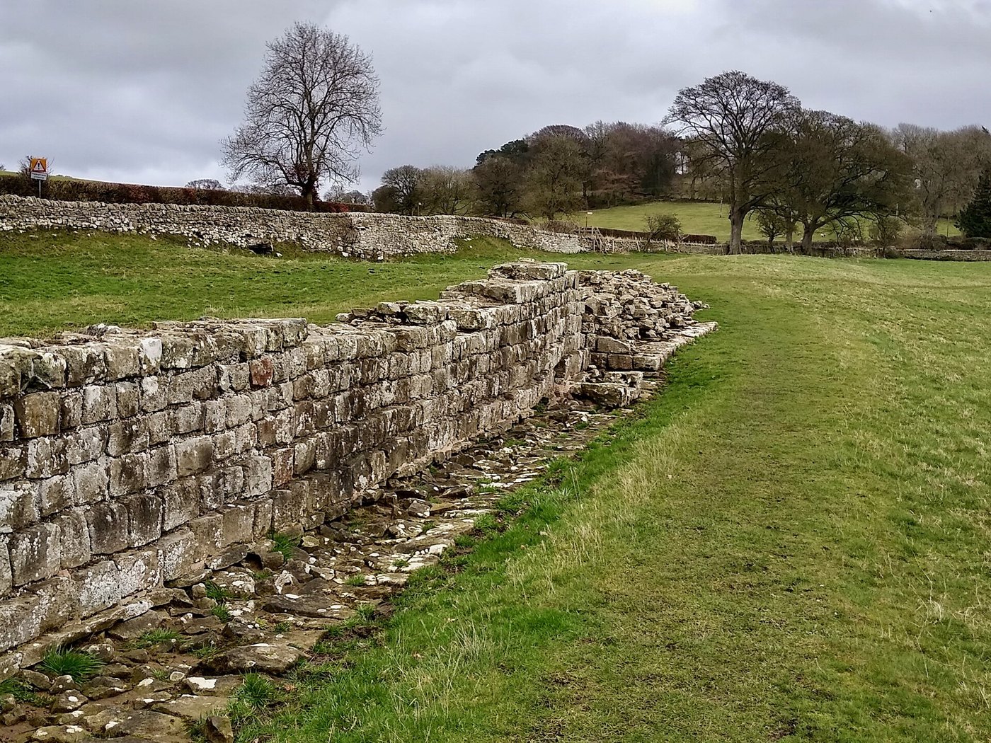
And then, while the work was still going on, the plan changed. The stone wall was narrowed. To 8 Roman feet, says Breeze, or less. You can still see it. The turrets were built before the wall reached them, with short stubs of wall at either side, ready to be joined. At Brunton turret, the stub on one side is broad. The wall that came up to it later is narrow, about 1.8 metres instead of 3. A change of plan, frozen in the masonry.
Who built it: signed by the century
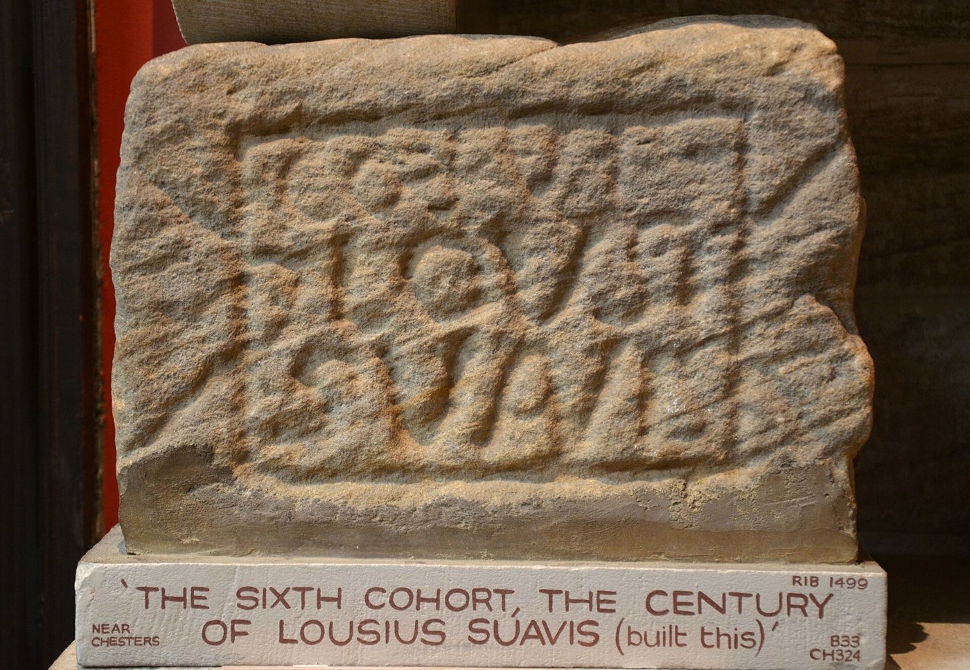
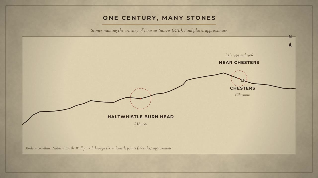
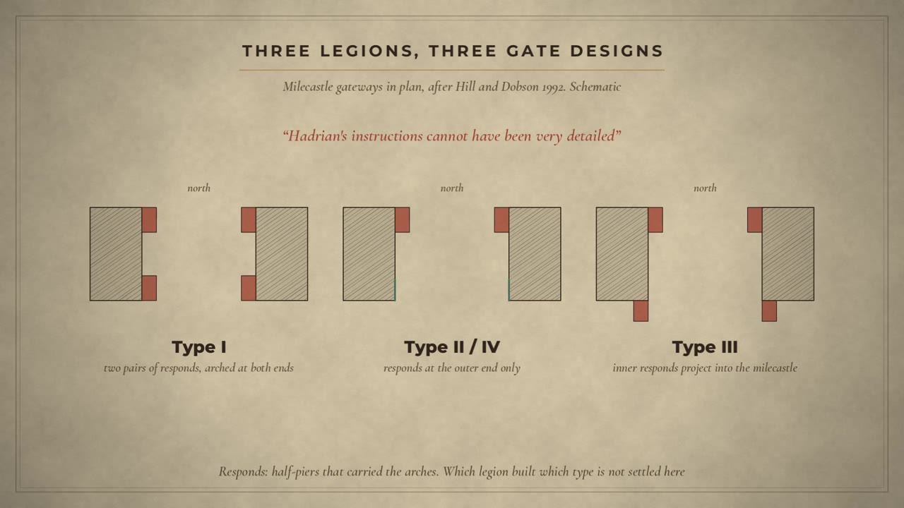
Who built it? Mainly the three legions in Britain, says Breeze, with help from auxiliary units and the fleet. And they signed their work. Small building stones name the unit that built a length of wall. This one was found near Chesters. From the sixth cohort, the century of Lousius Suavis. The standard edition of Roman inscriptions from Britain lists 5 more stones naming the same century, some of them more than 20 kilometres further west. The legions did not even build their milecastle gates alike. Hill and Dobson see three designs, from three legions. Hadrian's instructions, they write, cannot have been very detailed.
Forts and the Vallum
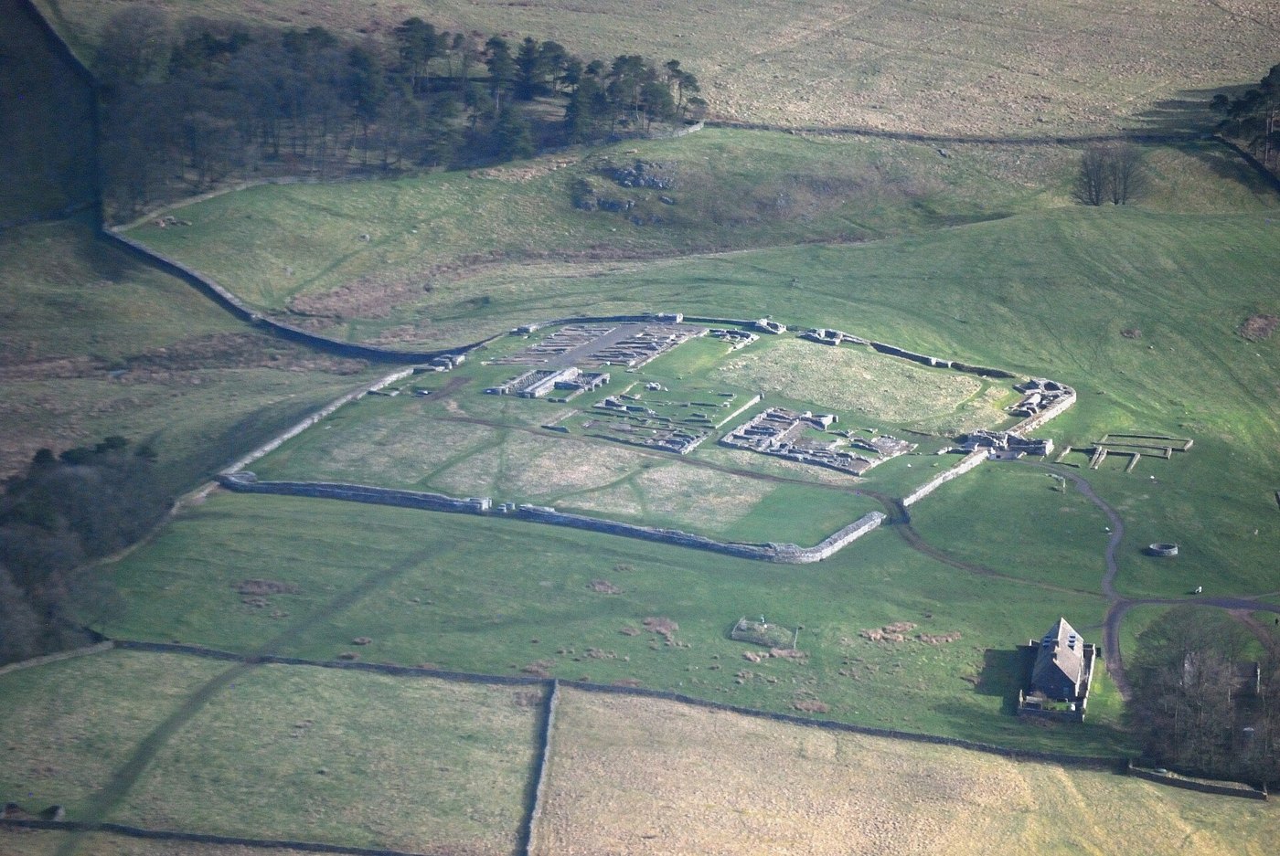
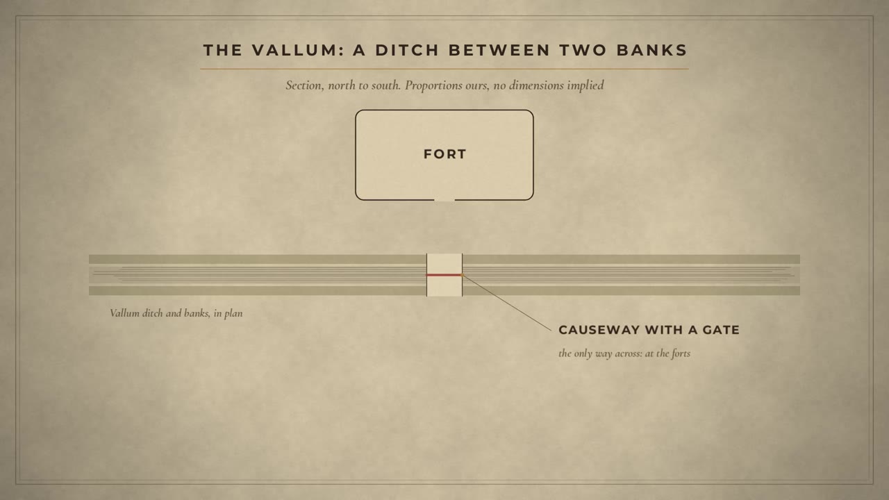
Then came the biggest change of all. Before the work was finished, 14 new forts were added, on the line of the Wall itself. Some went straight over what had already been built. At Housesteads, a turret now lies inside the fort walls. At Birdoswald, a turret was partly torn down to make room. And behind the Wall, to the south, came a vast earthwork: a ditch between two banks, along almost the whole length. We call it the Vallum. It could be crossed only at the forts, on causeways, through gates. Hill and Dobson put it bluntly. The forts and the Vallum are clear evidence that the original plan was flawed. Why it changed is argued over. Bidwell sees a response to resistance, and open warfare, beyond the frontier and behind it.
Branches on the berm
Now a discovery made only in this century. Around the year 2000, rescue excavations at Shields Road, in Newcastle, found pits on the strip of ground between the Wall and its ditch. Three rows of them, staggered, each pit holding the bases of two obstacles. Probably forked branches, with sharpened ends. Caesar, at the siege of Alesia from our scorpion episode, says his soldiers called such things cippi. A thicket of sharpened branches, right in front of the Wall. They have since been found at several places on Tyneside. Did they run the whole length? Nobody knows. Very little of that strip has ever been dug.
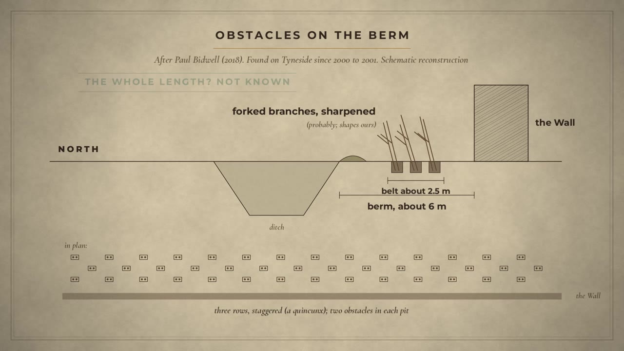
Did you know? Since rescue excavations at Shields Road in Newcastle around 2000, three staggered rows of pits for obstacles, probably forked and sharpened branches, have been found in front of the Wall on Tyneside. Caesar says his soldiers at Alesia called such obstacles cippi (Bidwell 2018; Caesar, Gallic War 7.73).
What was it for? A walkway on top?
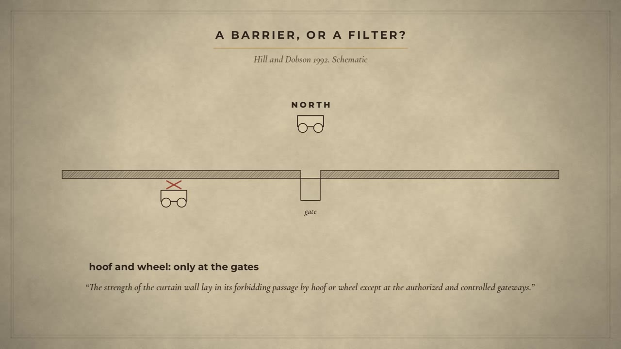
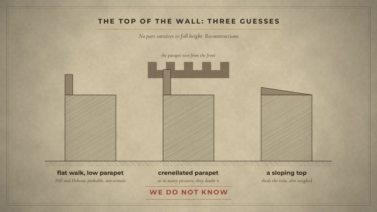
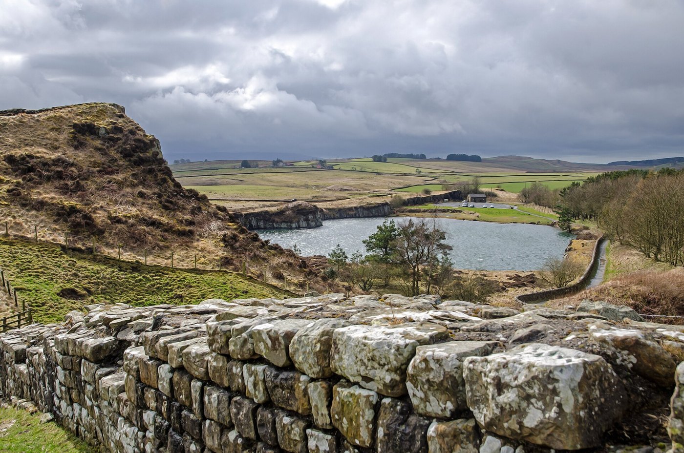
So what was the Wall for? The Historia Augusta says: to separate the barbarians from the Romans. Hill and Dobson saw it differently. Its strength, they wrote, lay in forbidding passage by hoof or wheel, except at the authorised and controlled gateways. Stopping men on foot was impossible. And was there a walkway along the top, with battlements, as in so many pictures? We do not know. No part of the Wall survives to its full height. It was wide enough for a walkway, says Breeze. Hill and Dobson thought a parapet likely, but not battlements for fighting, and they weighed a top that simply sloped, to shed the rain. A book published in 2025 still has whole chapters on the question. So our drawings of the top are reconstructions.
After Hadrian
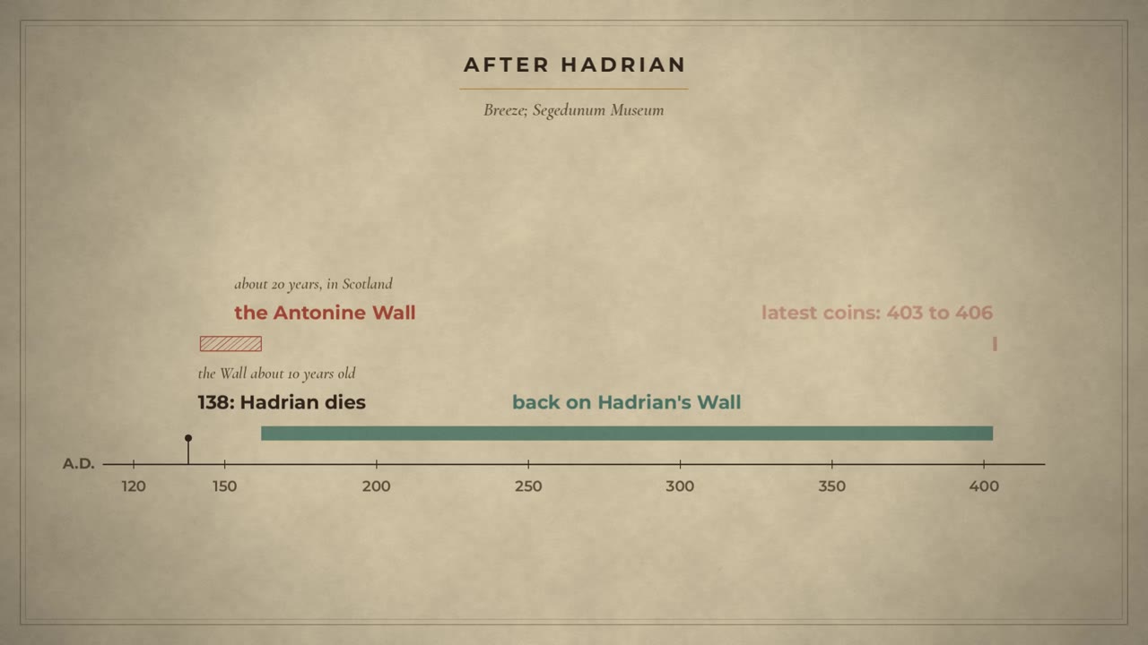
The Wall had stood for only about ten years when Hadrian died. His successor, Antoninus Pius, built a new wall far to the north, in Scotland. It lasted about twenty years. Then the army came back to Hadrian's Wall, and stayed. The latest coins found along it were struck between 403 and 406.
The first souvenirs, and the Wall's name
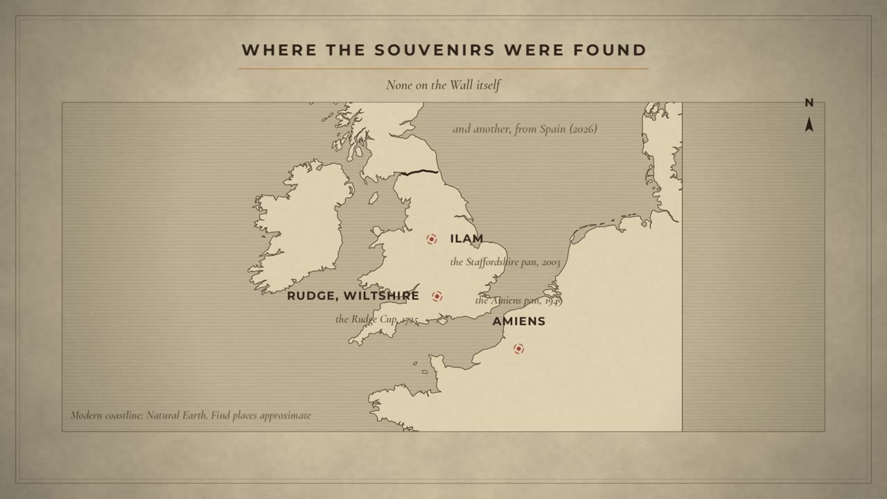
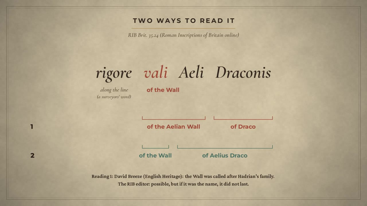
Which brings us back to the pan. It is not alone. A cup found in 1725, in a well at a Roman villa in Wiltshire, names five forts of the Wall, and shows a wall with towers in enamel. Another, found at Amiens in France in 1949, names six. A book edited by David Breeze calls them the first souvenirs. And in 2026, another was announced, from Spain. By one count, the group now numbers six. So, rigore vali Aeli Draconis. Rigore is a surveyor's word: along the line. Vali: of the Wall. Then either: of the Aelian Wall, and a man called Draco. Or a man called Aelius Draco, perhaps the soldier who had it made. Breeze takes the first reading: the Wall was called after Hadrian's family. The pan's editor thinks that possible too, but if it was the name, it did not last. If Breeze is right, the Wall's Roman name has come down to us on a souvenir pan.
What we really have
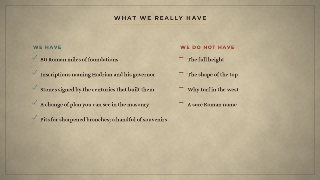
So, what do we really have? 80 Roman miles of foundations. Inscriptions naming Hadrian and his governor. Stones signed by the centuries that built them. A plan you can watch changing in the masonry. Pits for sharpened branches. A handful of souvenirs. What we don't have: the full height, the shape of the top, the reason for the turf, or a sure Roman name.
Verdict, and what comes next
So that's Hadrian's Wall. Not a sealed barrier, but a wall full of gates, rebuilt and rethought while it was still going up.
Questions for you (I read every comment and I answer): What do you think the Wall was for: to keep people out, or to control who came through its gates? The pan says rigore vali Aeli Draconis: was the Wall called the Aelian Wall, or is Aelius just part of a man's name?
Over to you
What do you think the Wall was for: to keep people out, or to control who came through its gates? The pan says rigore vali Aeli Draconis: was the Wall called the Aelian Wall, or is Aelius just part of a man's name?
Quick answers
Who built Hadrian's Wall?
Mainly the three legions in Britain, with help from auxiliary units and the fleet, says David Breeze. Building inscriptions name the emperor Hadrian and his governor Aulus Platorius Nepos, who governed Britain from about 122 to about 126, and small centurial stones name the units that built each length.
What do the ancient texts say about Hadrian's Wall?
Of the texts we know, one sentence credits Hadrian: the Historia Augusta says he was the first to build a wall, eighty miles long, to separate the barbarians from the Romans. That collection was written more than 200 years later. Its life of Septimius Severus says Severus built a wall from sea to sea, and Bede, in the eighth century, gives Severus a turf rampart and dates the stone wall to the end of Roman Britain.
How high was Hadrian's Wall?
Nowhere does it survive to its full height. From the remains of two milecastles, Peter Hill and Brian Dobson worked out a design height of about fifteen Roman feet, some four and a half metres. Whether there was a walkway with a parapet on top is still debated.
Why was part of Hadrian's Wall built of turf?
West of the river Irthing, about the western thirty of the eighty miles, the Wall was first built as a turf rampart twenty Roman feet wide, with milecastles of turf and timber. The sources we read do not settle why. It was later replaced in stone.
What was the Roman name of Hadrian's Wall?
We do not know for sure. A small enamelled pan found in Staffordshire in 2003 reads rigore vali Aeli Draconis. David Breeze reads it as the Aelian Wall, after Hadrian's family name Aelius; it can also be read as the name of a man, Aelius Draco.
Where it happened
- Wallsend (Segedunum) (A.D. 125): The eastern end of the Wall. Pleiades 89288.
- Bowness-on-Solway (Maia) (A.D. 125): The western end of the Wall; named on the pan as Mais. Pleiades 89239.
- Milecastle 38 (Hotbank) (A.D. 122): Probable find place of RIB 1638, naming Hadrian and Platorius Nepos.
- Housesteads (Vercovicium) (A.D. 125): A fort added on the line of the Wall over turret 36b.
- Birdoswald (Banna) (A.D. 125): Turf Wall country; turret 49a partly demolished for the fort.
- Brunton turret (26b) (A.D. 122): Broad wing wall and narrow curtain. Position: between the Pleiades points of milecastles 26 and 27.
- Shields Road, Newcastle (A.D. 125): Obstacle pits on the berm found in rescue excavations in 2000 to 2001.
- Vindolanda (A.D. 100): A fort on the Stanegate, before the Wall.
- Near Ilam, Staffordshire (A.D. 130): Find place of the Staffordshire Moorlands pan (2003); exact spot not published.
- Jarrow (A.D. 731): Bede's monastery.
Sources
Ancient writers and modern work
All pages below were read on 2026-11-15. "Read" means the text itself was read (full text, or the passage quoted); "abstract" means only an
abstract, a publisher's description or a search summary was available, and the narration hedges accordingly. Claim-by-claim tags: `claims.md`.
Ancient and medieval texts
1. **Historia Augusta, Life of Hadrian 11.2 to 11.3.** Latin: The Latin Library, https://www.thelatinlibrary.com/sha/hadr.shtml
("murumque per octoginta milia passuum primus duxit, qui barbaros Romanosque divideret"). English: Loeb Classical Library 1921 (translation
by David Magie), on LacusCurtius, https://penelope.uchicago.edu/Thayer/E/Roman/Texts/Historia_Augusta/Hadrian/1*.html ("he set out for Britain,
and there he corrected many abuses and was the first to construct a wall, eighty miles in length, which was to separate the barbarians from the
Romans"). 11.3: Hadrian replaced Septicius Clarus and Suetonius Tranquillus, the secretary for letters (epistularum magister). Read.
Also 12.6 (the palisade of stakes in other provinces): read, not used.
2. **Historia Augusta, Life of Septimius Severus 18.2** with the Loeb note 129 ("This does not refer to the construction of a new wall, but to the
restoration probably of the wall of Hadrian"), LacusCurtius, https://penelope.uchicago.edu/Thayer/E/Roman/Texts/Historia_Augusta/Septimius_Severus*.html. Read.
3. **On the Historia Augusta as a source:** Jona Lendering, Livius.org, https://www.livius.org/sources/content/historia-augusta/ (composed before 425,
perhaps under Julian or Theodosius; one author behind six fake names, suggested by Hermann Dessau in 1889 and confirmed "beyond reasonable doubt" by
computer stylistics). Read. David Breeze (English Heritage, below) calls it "a biography written 200 years later".
4. **Bede, Ecclesiastical History, Book I, chapters 5 and 12** (Severus "not with a wall, as some imagine, but with a rampart" of sods; the stone wall
built by the Romans with the Britons' help at the end of Roman rule, "eight feet in breadth, and twelve in height ... as is still visible to
beholders"). Internet Medieval Sourcebook (Fordham), https://sourcebooks.fordham.edu/basis/bede-book1.asp; translation "not clearly indicated
(but it seems to be L. C. Jane's 1903 Temple Classics translation)". Book I does not mention the emperor Hadrian (checked in the full text).
Book V, chapter 24 (Bede a priest of the monastery at Wearmouth and Jarrow): https://sourcebooks.fordham.edu/basis/bede-book5.asp. Read.
5. **Caesar, Gallic War 7.73** (Alesia: sharpened branches in trenches, "hos cippos appellabant"), The Latin Library,
https://www.thelatinlibrary.com/caesar/gall7.shtml. Read.
Inscriptions and objects (Roman Inscriptions of Britain online)
6. **RIB 1638**, building inscription, probably from milecastle 38 (Hotbank): "Imp(eratoris) Caes(aris) Traian(i) Hadriani Aug(usti) leg(io) II
Aug(usta) A(ulo) Platorio Nepote leg(ato) pr(o) pr(aetore)"; dated A.D. 122 to about 126 by the governorship of Nepos; milecastle 39 built by
legio XX. https://romaninscriptionsofbritain.org/inscriptions/1638. Read.
7. **RIB 1499**, centurial stone found near Chesters, Chesters Museum CH324: "coh(ortis) VI (centuria) Lousi Suavis", "From the sixth cohort the
century of Lousius Suavis (built this)"; the same centurion on RIB 1506 (turret 28b), 1681 (Haltwhistle Burn Head), 1859 (Willowford East),
1861 and 3401 (Carvoran to Birdoswald sector). https://romaninscriptionsofbritain.org/inscriptions/1499 (and the RIB index pages for the
other five, seen as search summaries). Read (1499); the others as RIB titles and find places only.
8. **Brit. 35.24, the Staffordshire Moorlands (Ilam) pan**: found near Ilam, Staffordshire, in 2003 by a metal detectorist; British Museum
2005,1204.1; rim diameter 89.5 mm; inlaid roundels; text "rigore val(l)i Aeli Draconis Mais Conggabata Uxelodunum Cambmoglianna"; translated
"On the line of the Wall (or the Aelian Wall), belonging to Aelius Draco (or Draco)", then Mais (Bowness), Congavata (Drumburgh), Uxelodunum
(Stanwix), Camboglanna (Castlesteads); "rigore" a surveyors' term for a straight line; the editor considers "vallum Aelium" as the Wall's name
and thinks such a name probably did not last; suggests a souvenir for a discharged auxiliary veteran; dated about A.D. 125 to 140.
https://romaninscriptionsofbritain.org/inscriptions/Brit.35.24. Read (as a summary of the page; quoted phrases checked).
Secondary: Wikipedia "Staffordshire Moorlands Pan" (joint ownership British Museum, Tullie House, Potteries Museum, 2005), used only to find the
bibliography (R. Jackson in D. J. Breeze ed., The First Souvenirs, 2012). Not used for any narrated fact on its own.
9. **RIB 2415.53, the Rudge Cup**: found 1725 while excavating a well at a Roman villa at Rudge Coppice near Froxfield (Wiltshire); Alnwick Castle;
90 mm across; enamelled "masonry wall with crenellated towers", "interpreted as a schematic rendering of Hadrian's Wall"; five forts named
(Mais, Aballava, Uxelodunum, Camboglanna, Banna); the Amiens bowl, found 1949, adds Aesica.
https://romaninscriptionsofbritain.org/inscriptions/2415.53. Read.
Modern scholarship and heritage bodies
11. **David J. Breeze, "History of Hadrian's Wall"**, English Heritage, https://www.english-heritage.org.uk/visit/places/hadrians-wall/hadrians-wall-history-and-stories/history/
(built on Hadrian's orders after his visit in A.D. 122; HA quote; three legions plus auxiliaries and fleet; at least six years; Stanegate between
Corbridge and Carlisle; western 30 miles in turf, 20 Roman feet wide; stone wall about 15 feet high, "wide enough for there to have been a walkway";
narrowed to 8 Roman feet (2.4 m) or less; gate every mile, two turrets between, "observation points every third of a mile"; forts astride the
Wall; Vallum "presumably to protect the rear"; Antonine Wall about 20 years; latest coins A.D. 403 to 406; the Ilam pan "suggests that it was
called the vallum Aelii"). Read.
12. **English Heritage, "Description of Hadrian's Wall"**, https://www.english-heritage.org.uk/visit/places/hadrians-wall/hadrians-wall-history-and-stories/history/description/
("As first planned, the Wall consisted of a wall of stone or turf fronted by a wide and deep ditch"; milecastles numbered east to west;
"Before work was completed, 14 new forts were added, together with an earthwork known as the Vallum"). Read.
13. **James Crow, "History of Housesteads Roman Fort"**, English Heritage (turret 36b "now lies within the fort walls"; Wall at Housesteads resumed at a
narrower gauge). Read.
14. **Tony Wilmott, "History of Birdoswald Roman Fort"**, English Heritage, https://www.english-heritage.org.uk/visit/places/birdoswald-roman-fort-hadrians-wall/history-and-stories/history/
(west of the Irthing first built of turf; milecastles of turf and timber; turret 49a partly demolished for the fort; the first 5 miles of turf Wall
rebuilt in stone; "replaced in stone, following a different course"). Read. Also T. Wilmott, *Birdoswald* (English Heritage Archaeological Report
14, 1997), ADS PDF: read in part (Turf Wall, clay construction where no turf could be found); not quoted.
15. **English Heritage, "History of Brunton Turret"** (turret 26b; turrets built before the Wall with wing walls; narrowed "from 3 metres to 1.8
metres"; this stretch by the 20th Legion; broad wing wall to the east). Read. No author named.
16. **Paul Bidwell, "History of Benwell Vallum Crossing"**, English Heritage (the Vallum a ditch and two banks along the whole Wall except
Newcastle to Wallsend; "probably defined the rear of the military zone"; crossings only at the forts; a gate on the causeway). Read.
17. **P. R. Hill and B. Dobson, "The Design of Hadrian's Wall and its Implications"**, Archaeologia Aeliana 5th series 20 (1992), 27 to 52, ADS PDF.
Read in full: broad wall designed at 10 Roman feet (2.96 m); design height "almost certainly" 15 Roman feet (4.44 m), from milecastles 37 and 48;
"As the Wall has not survived to full height there is no firm evidence for the way in which it was finished off"; options: flat walk with
crenellated or straight parapet, or a sloping top; the milecastle gateways "seem to be the work of three different legions"; "Hadrian's
instructions cannot have been very detailed"; "The strength of the curtain wall lay in its forbidding passage by hoof or wheel except at the
authorized and controlled gateways. Prevention of any passage by men on foot was impossible to achieve"; a parapet "probably provided, but it was
in all probability not crenellated, and was not a fighting top"; "The building of forts on the line of the Wall and the creation of the Vallum
is clear evidence that the original plan was flawed."
18. **Paul Bidwell, "Hadrian's Frontiers in Northern Britain"**, Britannia 53 (2022), 99 to 124. ABSTRACT ONLY: Stage 1 incorporated much of the
Trajanic Stanegate frontier; forts added in Stages 2 to 4; Vallum in Stage 3; the modifications appear to respond to shifting loyalties,
resistance and open warfare beyond and behind the frontier. The narration says "Bidwell argues" / "Bidwell sees".
19. **Paul Bidwell, "Geophysical survey on Hadrian's Wall at Heddon-on-the-Wall"** (Arbeia Society, 6 August 2018), ADS PDF. Read: berm obstacles a
recent discovery from rescue excavations at Shields Road in 2000 to 2001; three rows of pits in a quincunx; each pit held the bases of two
obstacles, "probably forked branches with sharpened ends, described as cippi by Caesar"; found at several Tyneside sites; whether they ran the
whole length "remains uncertain ... very few excavations on the berm". Cites Bidwell 2005 (Arbeia Journal 8), McKelvey and Bidwell 2005,
McKelvey 2010, Platell 2012 (not read).
20. **Segedunum Roman Fort (Tyne and Wear Museums), "Hadrian's Wall: background information"** (education sheet), PDF. Read: 80 Roman miles (73 miles,
117 km); Wall built slightly north of the earlier forts-and-road frontier; "branch entanglements (like barbed wire)"; the completed Wall had
stood about 10 years when Hadrian died. Used for the length and the 10 years; the barbed-wire image is the museum's own analogy.
21. **D. A. Welsby and N. Hodgson (eds), *Hadrian's Wall: Milecastles, Turrets and the Curtain*** (Archaeopress, 2025). PUBLISHER'S DESCRIPTION AND
CONTENTS ONLY: chapters "Did Hadrian's Wall have a wall walk?" (Paul Bidwell) and on the chamfered string course and the Wall-top (Nick Hodgson);
"a question of long-running controversy because no part of the Wall survives to full height". Used only for "a book published in 2025 still has
whole chapters on the question".
22. **D. J. Breeze (ed.), *The First Souvenirs: Enamelled Vessels from Hadrian's Wall*** (CWAAS extra series 37, 2012). TITLE AND REVIEW SUMMARY ONLY
(Royal Archaeological Institute review, search summary). Used only for the book's title.
23. **Carly Hilts, "The Berlanga Cup"**, Current Archaeology 436 (4 June 2026), https://the-past.com/feature/the-berlanga-cup-examining-a-new-addition-to-the-hadrians-wall-souvenir-vessels/
Read as a summary: a cup found in Spain, recently announced in Britannia, makes six vessels in the group ("a sixth member of this enigmatic group"). The forts it names were not given in what we read.
Fact-check 2026-11-15: the Britannia paper (R. De Pablo Martínez et al. 2026, "The Berlanga Cup: new evidence of Hadrian's Wall pans found in Hispania Citerior") was press-reported in April 2026 (found near Berlanga de Duero, Soria; Museo Numantino; names Cilurnum, Onno, Vindobala, Condercum according to press summaries, not checked in the paper). Some reports call it "one of five", so the narration says "by one count" six.
Places and map data
24. **Pleiades** (CC BY 3.0), https://pleiades.stoa.org: representative points for milecastles 1 to 80 and for the forts Segedunum, Pons Aeli,
Condercum, Vindovala, Onnum, Cilurnum, Brocolitia, Turret 36B (inside Housesteads fort), (A)Esica, Magnis (Carvoran), Banna, Camboglanna,
Uxelodunum, Aballava, Congavata, Maia, Coria (Corbridge), Vindolanda, Luguvalium (Carlisle). Fetched 2026-11-15, stored in
`research/pleiades_milecastles.json` and `research/pleiades_out.json`. Our map draws the Wall as a line through the milecastle points
(labelled "line joined through the milecastles; approximate").
25. **Natural Earth 10 m** land (public domain), cropped by `research/make_geo.py`. Modern coastline. Rivers Tyne, Irthing and Eden are NOT in the
data and are drawn only as labelled points, not lines.
Image credits
- Hadrian's Wall near Housesteads today. Photo: Benjamin Smith, CC BY-SA 4.0
- The Staffordshire Moorlands (Ilam) pan, 2nd century A.D. Photo: Portable Antiquities Scheme, CC BY 2.0
- Marble bust of Hadrian in military dress, from Hadrian's Villa, Tivoli, about A.D. 117 to 118 (as labelled). British Museum. Photo: Following Hadrian (Carole Raddato), CC BY-SA 2.0
- Milecastle 39 (Castle Nick) today. Photo: Nilfanion, CC BY-SA 3.0
- The Saint Petersburg Bede, a manuscript of Bede's Ecclesiastical History, 8th century. Russian National Library. Public domain
- Milecastle 37 from the air, 2023. Photo: Lieven Smits, CC BY-SA 4.0
- Sestertius of Hadrian with BRITANNIA on the reverse, Rome, about A.D. 134 to 138. Photo: Classical Numismatic Group, CC BY-SA 2.5
- A road on the line of the Stanegate today. Photo: Clive Nicholson, CC BY-SA 2.0
- The line of the Turf Wall and the Vallum at High House today. Photo: Sandy Gerrard, CC BY-SA 2.0
- Birdoswald (Banna) fort from the air, 2026. Photo: DsMaxwell, CC BY-SA 4.0
- Brunton turret (26b) today. Photo: Jonathan Thacker, CC BY-SA 2.0
- The Wall at Planetrees today: the join between broad and narrow wall. Photo: Mertbiol, CC0
- Centurial stone of Lousius Suavis (RIB 1499), found near Chesters. Clayton Museum, Chesters. Photo: Carole Raddato, CC BY-SA 2.0
- Housesteads fort and the Wall from the air, 2023. Photo: Lieven Smits, CC BY-SA 4.0
- Hadrian's Wall at Walltown Crags today. Photo: Bobby Clegg, CC BY-SA 2.0
- The Wall at Cawfields today, above the old quarry. Photo: Sebastian Mierzwa, CC BY-SA 4.0
- The Bridgeness distance slab from the Antonine Wall: LEG II AVG, for Antoninus Pius. National Museum of Scotland. Photo: dun_deagh, CC BY-SA 2.0
- The Staffordshire Moorlands (Ilam) pan, showing part of the rim inscription. Photo: G. de la Bedoyere, public domain
- The Vallum near milecastle 42 today; the Wall on the ridge to the right. Photo: Voice of Clam, public domain
- Animations, maps and diagrams: original work, Spoken History. Map data: Natural Earth, public domain.
- Music: Chopin - Nocturne No. 21 in C minor, B. 108 (Diana Hughes): Frédéric Chopin; released to the public domain by Musopen (PD-author on the Commons file page)
- Music: Ludwig van Beethoven — Cello Sonata No. 3 (2nd movement): Ludwig van Beethoven; CC0 on the Commons file page
- Music: Schubert - Piano Sonata No. 19 in C minor, D958 - II. Adagio (Paul Pitman): Franz Schubert; released to the public domain by Musopen (PD-author on the Commons file page)
- Music: Beethoven - String Quartet No. 6 in B flat major, Op. 18 No. 6 - IV. La malinconia (Musopen String Quartet): Ludwig van Beethoven; released to the public domain by Musopen (PD-author on the Commons file page)
- Music: Chopin - Nocturne No. 10 in A-flat major, Op. 32 No. 2 (Olga Gurevich): Frédéric Chopin; released to the public domain by Musopen (PD-author on the Commons file page)
Transcript
Read the full narration
Hadrian's Wall. Turf, stone, and a gate every mile. Staffordshire, England. 2003. A metal detector turns up a little bronze pan, decorated with bright enamel. It is about 9 centimetres across. Small enough to hold in one hand. Around the rim runs a line of Latin, with no clear beginning and no clear end. In it, four names: Mais. Congavata. Uxelodunum. Camboglanna. They are Roman forts. All four stood at the western end of Hadrian's Wall, more than 200 kilometres to the north. And four more words. Rigore vali Aeli Draconis. Vali means: of the Wall. And Aelius was Hadrian's own family name. So this little pan may tell us something no ancient book does. What the Romans called the Wall. This is Hadrian's Wall. 80 Roman miles of stone and turf, right across Britain, from the river Tyne to the Solway. Today: what it was, what has been dug up, and what the texts really say. And the first surprise: the ancient writers almost never name Hadrian as its builder. Of the ancient texts we know, one sentence gives it to Hadrian. It is in the Historia Augusta, a collection of the lives of the emperors. Hadrian, it says, went to Britain, set many things right, and was the first to build a wall, 80 miles long, to separate the barbarians from the Romans. But handle it with care. The collection was written more than 200 years after Hadrian, and most scholars now think by one author, who pretends to be six. And in the very next sentence, it says Hadrian sacked his secretary for letters. His name was Suetonius. The same Suetonius who told us how Caesar died, in our pugio episode. Later writers muddled it. The same collection, in its life of the emperor Septimius Severus, says that Severus built a wall across Britain, from sea to sea. A note in its Loeb edition of 1921 says this probably means a restoration of Hadrian's wall. And the monk Bede, at Jarrow, just a few miles from the Wall's eastern end, gives a different story again. Severus, he says, built a rampart of turf. The stone wall was built by the Romans, with the Britons' help, at the very end of Roman Britain. Eight feet broad, twelve feet high, and, he says, still to be seen. Hadrian is not in his story at all. So how do we know it was Hadrian? From the stones themselves. This inscription probably comes from milecastle 38, in the middle of the Wall. The work of the emperor Caesar Trajan Hadrian Augustus. The Second Legion Augusta built it, under Aulus Platorius Nepos, the governor. Platorius Nepos governed Britain from about 122 to about 126. 122 is the year Hadrian came to Britain. And, says the archaeologist David Breeze, the Wall was built on his orders after that visit. Hadrian did not start from nothing. Across this narrow neck of Britain, forts already stood along a road we now call the Stanegate, between Corbridge and Carlisle. Vindolanda, from our fort episode, was one of them. Paul Bidwell argues that Hadrian's first plan took in much of that older line. The Wall itself ran a little further north. As first planned, the Wall was a wall of stone or turf, with a wide, deep ditch in front of it. At every Roman mile, about one and a half kilometres, there was a gate, guarded by a small fort we call a milecastle. Between each pair of milecastles stood two towers, called turrets. A lookout every third of a mile. A barrier with a gate roughly every mile. About eighty gates through a wall meant to separate. In the east, the stone wall was planned 10 Roman feet thick. About 3 metres. How high? Nowhere does it survive to its full height. From the remains of two milecastles, Peter Hill and Brian Dobson worked out a design height of about 15 Roman feet. Some 4.5 metres. But the west was different. Beyond the river Irthing, the Wall was first built of turf. About the western 30 miles of the 80. A rampart 20 Roman feet wide, about 6 metres, with milecastles of turf and timber. Why turf? The sources we read don't settle it. Later, the turf was replaced in stone. At Birdoswald, the new stone wall even took a different line. And then, while the work was still going on, the plan changed. The stone wall was narrowed. To 8 Roman feet, says Breeze, or less. You can still see it. The turrets were built before the wall reached them, with short stubs of wall at either side, ready to be joined. At Brunton turret, the stub on one side is broad. The wall that came up to it later is narrow, about 1.8 metres instead of 3. A change of plan, frozen in the masonry. If you are enjoying this type of content, please don't forget to subscribe. Who built it? Mainly the three legions in Britain, says Breeze, with help from auxiliary units and the fleet. And they signed their work. Small building stones name the unit that built a length of wall. This one was found near Chesters. From the sixth cohort, the century of Lousius Suavis. The standard edition of Roman inscriptions from Britain lists 5 more stones naming the same century, some of them more than 20 kilometres further west. The legions did not even build their milecastle gates alike. Hill and Dobson see three designs, from three legions. Hadrian's instructions, they write, cannot have been very detailed. Then came the biggest change of all. Before the work was finished, 14 new forts were added, on the line of the Wall itself. Some went straight over what had already been built. At Housesteads, a turret now lies inside the fort walls. At Birdoswald, a turret was partly torn down to make room. And behind the Wall, to the south, came a vast earthwork: a ditch between two banks, along almost the whole length. We call it the Vallum. It could be crossed only at the forts, on causeways, through gates. Hill and Dobson put it bluntly. The forts and the Vallum are clear evidence that the original plan was flawed. Why it changed is argued over. Bidwell sees a response to resistance, and open warfare, beyond the frontier and behind it. Now a discovery made only in this century. Around the year 2000, rescue excavations at Shields Road, in Newcastle, found pits on the strip of ground between the Wall and its ditch. Three rows of them, staggered, each pit holding the bases of two obstacles. Probably forked branches, with sharpened ends. Caesar, at the siege of Alesia from our scorpion episode, says his soldiers called such things cippi. A thicket of sharpened branches, right in front of the Wall. They have since been found at several places on Tyneside. Did they run the whole length? Nobody knows. Very little of that strip has ever been dug. So what was the Wall for? The Historia Augusta says: to separate the barbarians from the Romans. Hill and Dobson saw it differently. Its strength, they wrote, lay in forbidding passage by hoof or wheel, except at the authorised and controlled gateways. Stopping men on foot was impossible. And was there a walkway along the top, with battlements, as in so many pictures? We do not know. No part of the Wall survives to its full height. It was wide enough for a walkway, says Breeze. Hill and Dobson thought a parapet likely, but not battlements for fighting, and they weighed a top that simply sloped, to shed the rain. A book published in 2025 still has whole chapters on the question. So our drawings of the top are reconstructions. The Wall had stood for only about ten years when Hadrian died. His successor, Antoninus Pius, built a new wall far to the north, in Scotland. It lasted about twenty years. Then the army came back to Hadrian's Wall, and stayed. The latest coins found along it were struck between 403 and 406. Which brings us back to the pan. It is not alone. A cup found in 1725, in a well at a Roman villa in Wiltshire, names five forts of the Wall, and shows a wall with towers in enamel. Another, found at Amiens in France in 1949, names six. A book edited by David Breeze calls them the first souvenirs. And in 2026, another was announced, from Spain. By one count, the group now numbers six. So, rigore vali Aeli Draconis. Rigore is a surveyor's word: along the line. Vali: of the Wall. Then either: of the Aelian Wall, and a man called Draco. Or a man called Aelius Draco, perhaps the soldier who had it made. Breeze takes the first reading: the Wall was called after Hadrian's family. The pan's editor thinks that possible too, but if it was the name, it did not last. If Breeze is right, the Wall's Roman name has come down to us on a souvenir pan. So, what do we really have? 80 Roman miles of foundations. Inscriptions naming Hadrian and his governor. Stones signed by the centuries that built them. A plan you can watch changing in the masonry. Pits for sharpened branches. A handful of souvenirs. What we don't have: the full height, the shape of the top, the reason for the turf, or a sure Roman name. So that's Hadrian's Wall. Not a sealed barrier, but a wall full of gates, rebuilt and rethought while it was still going up. What do you think it was for? To keep people out, or to control who came through its gates? And the pan: was it the Aelian Wall? Or is Aelius just part of a man's name? If you enjoy history that checks its sources, a like and a subscribe help me keep making it. And write me a comment with your answers. I read every one, and I answer. Thanks for watching, and I'll see you in the next one. It's on your screen right now. Tap it, and I'll see you there.
All 29 topics
More episodes
The Roman Fort: Inside Vindolanda
Vindolanda, just south of Hadrian's Wall, is not one Roman fort but many, built one on top of another from about A.D. 85. The textbook plan of a fort and what the ancient texts really say...
Read the story
The Roman Scorpion: Rome's Sniper Weapon
A Gaulish warrior on a burning wall is hit by a bolt from a machine he never saw. The Roman scorpion was a torsion bolt-shooter powered by twisted sinew and hair. How it worked, who built...
Read the story
What Is a Caltrop?
A few centimetres of iron with four spikes, so shaped that one point always stands up. What the Romans called it, the story of buried caltrops at Gaugamela that only Curtius tells, Vegetius...
Read the story
What Was a Pugio?
A coin struck by Caesar's killers shows two daggers. The pugio, Rome's short dagger, appears in the stories of Caesar, Scaevinus, Arria and Sertorius, none of them a battle. What museums...
Read the story
Roman Helmets: From Montefortino to Imperial Gallic
Caesar writes that at the Sabis in 57 B.C. his men had no time even to put on their helmets. What were Roman helmets really? The modern type names (Montefortino, Coolus, Hagenau, Weisenau...
Read the story
What Was the Gladius, Really? Rome's Sword
Livy says Philip V's soldiers were horrified by the wounds of the Spanish sword. What was the Roman gladius, really? The origin story in the Suda and the dispute over when and from whom...
Read the story
Lorica Segmentata: The Armour from Corbridge
In 1964 a training dig at Corbridge, close to Hadrian's Wall, found a chest buried under a floor with twelve unmatched sections of Roman plate armour. What the lorica segmentata was, why...
Read the story
Roman Sling Bullets: Insults Cast in Lead
Roman lead sling bullets, the glandes: how they were cast, what the inscribed bullets from Octavian's siege of Perusia (41 to 40 B.C.) say, the disputed story of three hundred sacrificed at...
Read the story
The Roman Onager: Rome's One-Armed Stone-Thrower
A one-armed Roman stone-thrower, named after a wild ass, shook Persian siege towers apart at Amida in A.D. 359. How it worked, how it was crewed and carried, what it really did, and what...
Read the story